Bar nearby Seismic Gastrobar
New Zealand
Bar nearby Seismic Gastrobar
Seismic Gastrobar
1158 Whakaue Street, Rotorua Neuseeland
contacts phone
:
+64
Latitude:
-38.1331151
, Longitude:
176.2519558
read more
nearest Bar
24 m
Sobar
1096 Tutanekai Street, Rotorua
Bar
read more
60 m
BREW | Craft Beer Pub
1103 Tutanekai Street, Rotorua
Bar
read more
70 m
Craft Bar And Kitchen
1115 Tutanekai Street, Rotorua
Bar
read more
71 m
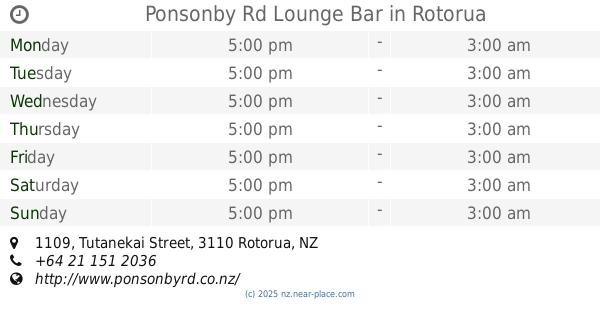
Ponsonby Rd Lounge Bar
1109 Tutanekai Street, Rotorua
Bar
read more
97 m
Lone Star Cafe & Bar Rotorua
1182 Whakaue Street, Rotorua
Bar
read more
120 m
Regent of Rotorua Boutique Hotel
1191 Pukaki Street, Rotorua
Bar
read more
152 m
Clarks Bar
Rotorua
Bar
read more
218 m
Rotorua Citizens Club
1146 Rangiuru Street, Rotorua
Bar
read more
278 m
Pig & Whistle, Historic Pub
1182 Tutanekai Street, Rotorua
Bar
read more
303 m
Fuze City Bar
312 Tutanekai Street, Rotorua
Bar
read more
320 m
Kiwi Spirit Bar
Rotorua
Bar
read more
327 m
Princes Gate Hotel
1057 Arawa Street, Rotorua
Bar
read more
373 m
Hennessy's Irish Bar
1210 Tutanekai Street, Rotorua
Bar
read more
420 m
Lava Bar The
1286 Arawa Street, Rotorua
Bar
read more
457 m
Stix Bar
1237 Pukuatua Street, Rotorua
Bar
read more
484 m
Sidepocket
1129 Hinemoa Street, Rotorua
Bar
read more
565 m
Vault Bar
1122 Hinemoa Street, Rotorua
Bar
read more
673 m
After Dark Caberet
Pukuatua Street, Hillcrest, Rotorua
Bar
read more
676 m
Ruck 'n Maul
1279 Amohia Street, Rotorua
Bar
read more
680 m
The Lake Road Tavern Sports Bar
41 Lake Road, Ohinemutu, Rotorua
Bar
read more
695 m
Bar Zazu
1270 Hinemaru Street, Rotorua
Bar
read more
705 m
kaspers Bar
1302 Tutanekai Street, Rotorua
Bar
read more
717 m
Our Backyard Pub
1287 Eruera Street, Rotorua
Bar
read more
975 m
The Backyard Inn
60 Tarewa Road, Rotorua
Bar
read more
1.739 km
Rydges Rotorua
272 Fenton Street, Glenholme, Rotorua
Bar
read more
📑
all categories
Accounting
Administrative area level 1
Administrative area level 2
Airport
Amusement park
Aquarium
Art gallery
Atm
Bakery
Bank
Bar
Beauty salon
Bicycle store
Book store
Bowling alley
Bus station
Cafe
Campground
Car dealer
Car rental
Car repair
Car wash
Casino
Cemetery
Church
City hall
Clothing store
Colloquial area
Convenience store
Country
Courthouse
Dentist
Department store
Doctor
Electrician
Electronics store
Embassy
Establishment
Finance
Fire station
Florist
Food
Funeral home
Furniture store
Gas station
General contractor
Grocery or supermarket
Gym
Hair care
Hardware store
Health
Hindu Temple
Home goods store
Hospital
Insurance agency
Jewelry store
Laundry
Lawyer
Library
Light rail station
Liquor store
Local government office
Locality
Locksmith
Lodging
Meal delivery
Meal takeaway
Mosque
Movie rental
Movie theater
Moving company
Museum
Natural feature
Neighborhood
Night club
Painter
Park
Parking
Pet store
Pharmacy
Physiotherapist
Place of worship
Plumber
Point of interest
Police
Political
Post office
Premise
Real estate agency
Restaurant
Roofing contractor
Route
Rv park, camping
School
Shoe store
Shopping mall
Spa
Stadium
Storage
Store
Subpremise
Supermarket
Synagogue
Taxi stand
Train station
Transit station
Travel agency
University
Veterinary care
Zoo
sublocality level 1
↑