Cafe nearby Classic Bakery Cafe
New Zealand
Cafe nearby Classic Bakery Cafe
Classic Bakery Cafe
15, Tamamutu Street, 3377, Taupo, NZ Neuseeland
contacts phone
:
+64
Latitude:
-38.6859553
, Longitude:
176.0708229
larger map & directions
read more
nearest Cafe
40 m
The Fern Cafe
11 Tamamutu Street, Taupo Central, Taupo
Cafe
read more
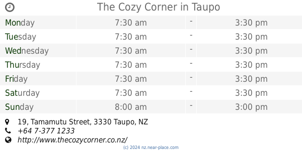
83 m
The Cozy Corner
Shop 15, Suncourt Plaza, 19 Tamamutu Street, Taupo
Cafe
read more
88 m
Bubble Delicious Tea
Taupo
Cafe
read more
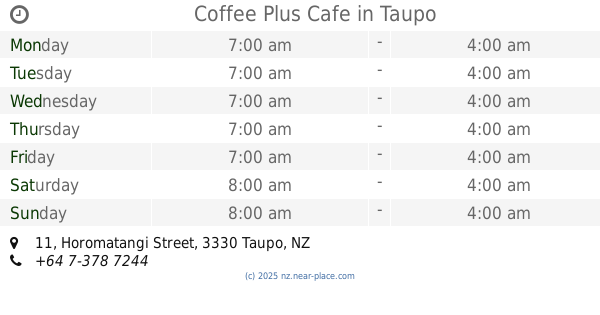
111 m
Coffee Plus Cafe
11 Horomatangi Street, Taupo
Cafe
read more
125 m
Victoria's Cafe Kitchen Bar
127 Tongariro Street, Taupo
Cafe
read more
154 m
Body Fuel Cafe
67 Tongariro Street, Taupo
Cafe
read more
162 m
Saluté Deli
47 Horomatangi Street, Taupo
Cafe
read more
167 m
Baked With Love - Eatery
2 Marama Arcade, Taupo
Cafe
read more
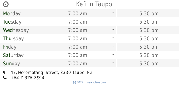
172 m
Kefi
47 Horomatangi Street, Taupo
Cafe
read more
193 m
Fine Fettle Cafe
39 Paora Hapi Street, Taupo Town Centre
Cafe
read more
203 m
Streetwise Coffee Taupo (Heu Heu Street)
30 Heuheu Street, Taupo
Cafe
read more
203 m
Streetwise Coffee Taupo (Heu Heu Street)
30 Heu Heu Street, Taupo
Cafe
read more
222 m
Robert Harris
11 Heuheu Street, Taupo
Cafe
read more
225 m
The Crafted Cup
Ruapehu Street, Taupo
Cafe
read more
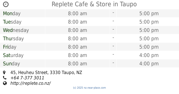
257 m
Replete Cafe & Store
45 Heuheu Street, Taupo
Cafe
read more
273 m
Wild Bean Café
48 Heuheu Street, Taupo
Cafe
read more
333 m
Piccolo Cafe
41 Ruapehu Street, Taupo
Cafe
read more
340 m
Taylors Landing Cafe
Redoubt Street, Taupo
Cafe
read more
403 m
Taste Cafe
10 Roberts Street, Taupo Town Centre
Cafe
read more
403 m
Jj's Cafe & Bar On The Lakefront
10 Roberts Street, Taupo
Cafe
read more
421 m
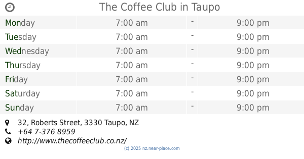
The Coffee Club
32 Roberts Street, Taupo
Cafe
read more
481 m
Spoon & Paddle
101 Heuheu Street, Taupo
Cafe
read more
494 m
Stir Cafe
59 Redoubt Street, Taupo
Cafe
read more
1.051 km
BUBU Coffee Roasters
Rangatira shopping center, 2 Mansell Road, Nukuhau, Taupo
Cafe
read more
1.059 km
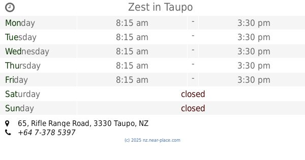
Zest
65 Rifle Range Road, Taupo
Cafe
read more
📑
all categories
Accounting
Administrative area level 1
Administrative area level 2
Airport
Amusement park
Aquarium
Art gallery
Atm
Bakery
Bank
Bar
Beauty salon
Bicycle store
Book store
Bowling alley
Bus station
Cafe
Campground
Car dealer
Car rental
Car repair
Car wash
Casino
Cemetery
Church
City hall
Clothing store
Colloquial area
Convenience store
Country
Courthouse
Dentist
Department store
Doctor
Electrician
Electronics store
Embassy
Establishment
Finance
Fire station
Florist
Food
Funeral home
Furniture store
Gas station
General contractor
Grocery or supermarket
Gym
Hair care
Hardware store
Health
Hindu Temple
Home goods store
Hospital
Insurance agency
Jewelry store
Laundry
Lawyer
Library
Light rail station
Liquor store
Local government office
Locality
Locksmith
Lodging
Meal delivery
Meal takeaway
Mosque
Movie rental
Movie theater
Moving company
Museum
Natural feature
Neighborhood
Night club
Painter
Park
Parking
Pet store
Pharmacy
Physiotherapist
Place of worship
Plumber
Point of interest
Police
Political
Post office
Premise
Real estate agency
Restaurant
Roofing contractor
Route
Rv park, camping
School
Shoe store
Shopping mall
Spa
Stadium
Storage
Store
Subpremise
Supermarket
Synagogue
Taxi stand
Train station
Transit station
Travel agency
University
Veterinary care
Zoo
sublocality level 1
↑