Park nearby Johnston Hill Scenic Reserve
New Zealand
Park nearby Johnston Hill Scenic Reserve
Johnston Hill Scenic Reserve
Hatton Street, 6012, Wellington, NZ New Zealand
contacts phone
:
+64 4-499 1400
website:
wellington.govt.nz
Latitude:
-41.2757285
, Longitude:
174.7418632
larger map & directions
read more
nearest Park
215 m
Johnston Hill Scenic Reserve
Karori, Wellington
Park
read more
226 m
Johnston Hill Scenic Reserve
Karori
Park
read more
503 m
Skyline Walkway
Karori, Wellington
Park
read more
595 m
Skyline Walkway
147/165 Parkvale Road, Karori, Wellington
Park
read more
990 m
Otari Wiltons Bush
Unnamed Road, Wilton, Wellington
Park
read more
1.011 km
Forte Gardening
6 Alanbrooke Place, Karori, Wellington
Park
read more
1.176 km
Ian Galloway Park
Curtis Street, Northland
Park
read more
1.221 km
Wilton Park
Wilton
Park
read more
1.229 km
Surrey Street Play Area
Wilton
Park
read more
1.41 km
Ben Burn Park
Campbell Street, Karori, Wellington
Park
read more
1.531 km
Appleton Park
Karori, Wellington
Park
read more
1.535 km
Skyline Reserve
Karori, Wellington
Park
read more
1.558 km
Troup Picnic Lawn, Otari-Wilton's Bush Reserve
Unnamed Road, Wilton, Wellington
Park
read more
1.596 km
Otari-Wilton's Bush
160 Wilton Road, Wilton, Wellington
Park
read more
1.658 km
Warwick Street Play Area
Wilton
Park
read more
1.683 km
Northland Park
Northland, Wellington
Park
read more
1.734 km
Glamorgan Street Play Area
Northland
Park
read more
1.832 km
Burrows Avenue Park
Karori
Park
read more
1.871 km
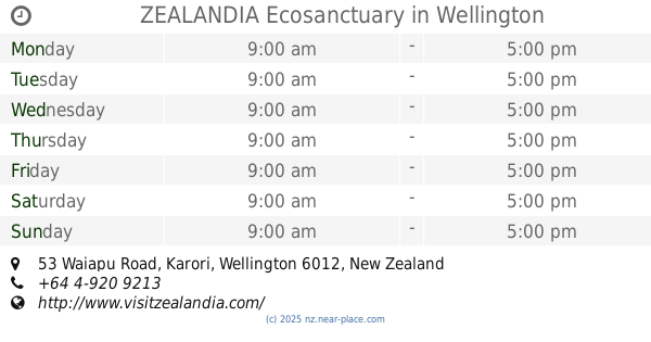
ZEALANDIA Ecosanctuary
53 Waiapu Road, Karori, Wellington
Park
read more
1.88 km
Karori Park Store
418 Karori Road, Karori, Wellington
Park
read more
1.9 km
Western Slopes Reserve
Wilton
Park
read more
2.024 km
Magpie Lawn
Botanic Gardens, Wellington
Park
read more
2.177 km
Izard Park
Wilton
Park
read more
2.301 km
Skyline Walkway
Crofton Downs, Wellington
Park
read more
2.679 km
Makara Peak Mountain Bike Park: Saint Albans Ave Entrance
Saint Albans Avenue, Karori, Wellington
Park
read more
📑
all categories
Accounting
Administrative area level 1
Administrative area level 2
Airport
Amusement park
Aquarium
Art gallery
Atm
Bakery
Bank
Bar
Beauty salon
Bicycle store
Book store
Bowling alley
Bus station
Cafe
Campground
Car dealer
Car rental
Car repair
Car wash
Casino
Cemetery
Church
City hall
Clothing store
Colloquial area
Convenience store
Country
Courthouse
Dentist
Department store
Doctor
Electrician
Electronics store
Embassy
Establishment
Finance
Fire station
Florist
Food
Funeral home
Furniture store
Gas station
General contractor
Grocery or supermarket
Gym
Hair care
Hardware store
Health
Hindu Temple
Home goods store
Hospital
Insurance agency
Jewelry store
Laundry
Lawyer
Library
Light rail station
Liquor store
Local government office
Locality
Locksmith
Lodging
Meal delivery
Meal takeaway
Mosque
Movie rental
Movie theater
Moving company
Museum
Natural feature
Neighborhood
Night club
Painter
Park
Parking
Pet store
Pharmacy
Physiotherapist
Place of worship
Plumber
Point of interest
Police
Political
Post office
Premise
Real estate agency
Restaurant
Roofing contractor
Route
Rv park, camping
School
Shoe store
Shopping mall
Spa
Stadium
Storage
Store
Subpremise
Supermarket
Synagogue
Taxi stand
Train station
Transit station
Travel agency
University
Veterinary care
Zoo
sublocality level 1
↑